 Government of India
Dholavira
The ancient city of Dholavira, the southern centre of the Harappan Civilization, is sited on the arid island of Khadir in the State of Gujarat. Occupied between ca. 3000-1500 BCE, the archaeological site, one of the best preserved urban settlements from the period in Southeast Asia, comprises a fortified city and a cemetery. Two seasonal streams provided water, a scarce resource in the region, to the walled city which comprises a heavily fortified castle and ceremonial ground as well as streets and houses of different proportion quality which testify to a stratified social order. A sophisticated water management system demonstrates the ingenuity of the Dholavira people in their struggle to survive and thrive in a harsh environment. The site includes a large cemetery with cenotaphs of six types testifying to the Harappan’s unique view of death. Bead processing workshops and artifacts of various kinds such as copper, shell, stone, jewellery of semi-precious stones, terracotta, gold, ivory and other materials have been found during archaeological excavations of the site, exhibiting the culture’s artistic and technological achievements. Evidence for inter-regional trade with other Harappan cities, as well as with cities in the Mesopotamia region and the Oman peninsula have also been discovered.
Outstanding Universal Value
Brief synthesis
Dholavira: a Harappan city, is one of the very few well preserved urban settlements in South Asia dating from the 3rd to mid-2nd millennium BCE. Being the 6th largest of more than 1,000 Harappan sites discovered so far, and occupied for over 1,500 years, Dholavira not only witnesses the entire trajectory of the rise and fall of this early civilization of humankind, but also demonstrates its multifaceted achievements in terms of urban planning, construction techniques, water management, social governance and development, art, manufacturing, trading, and belief system. With extremely rich artefacts, the well-preserved urban settlement of Dholavira depicts a vivid picture of a regional centre with its distinct characteristics, that also contributes significantly to the existing knowledge of Harappan Civilization as a whole.
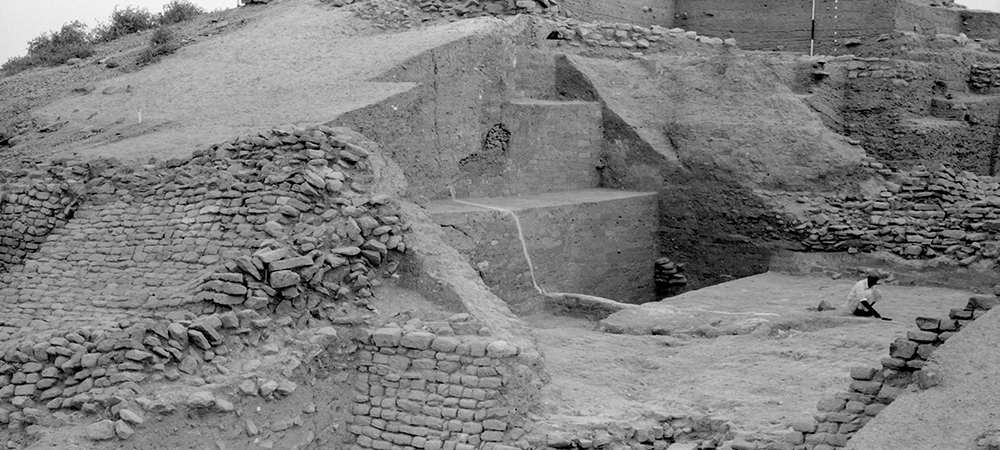
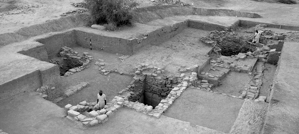
The property comprises two parts: a walled city and a cemetery to the west of the city. The walled city consists of a fortified Castle with attached fortified Bailey and Ceremonial Ground, and a fortified Middle Town and a Lower Town. A series of reservoirs are found to the east and south of the Citadel. The great majority of the burials in the Cemetery are memorial in nature.
The configuration of the city of Dholavira, during its heyday, is an outstanding example of planned city with planned and segregated urban residential areas based on possibly differential occupational activities, and a stratified society. Technological advancements in water harnessing systems, water drainage systems as well architecturally and technologically developed features are reflected in the design, execution, and effective harnessing of local materials. Unlike other Harappan antecedent towns normally located near to rivers and perennial sources of water, the location of Dholavira in the island of Khadir was strategic to harness different mineral and raw material sources (copper, shell, agate-carnelian, steatite, lead, banded limestone, among others) and to facilitate internal as well as external trade to the Magan (modern Oman peninsula) and Mesopotamian regions.
Criterion (iii): Dholavira is an exceptional example of a proto-historic Bronze Age urban settlement pertaining to the Harappan Civilization (early, mature and late Harappan phases) and bears evidence of a multi-cultural and stratified society during the 3rd and 2nd millennia BCE. The earliest evidence can be traced back to 3000 BCE during the early Harappan phase of the Harappan Civilization. This city flourished for nearly 1,500 years, representing a long continuous habitation. The excavated remains clearly indicate the origin of the settlement, its growth, zenith and the subsequent decline in the form of continuous changes in the configuration of the city, architectural elements and various other attributes.
Criterion (iv): Dholavira is an outstanding example of Harappan urban planning, with its preconceived city planning, multi-layered fortifications, sophisticated water reservoirs and drainage system, and the extensive use of stone as a building material. These characteristics reflect the unique position Dholavira held in the entire gamut of Harappan Civilization.
Integrity
The ancient Harappan city of Dholavira was discovered in 1968 and excavated for 13 field seasons between 1989 and 2005. The unearthed excavations were simultaneously preserved and conserved, and display all physical attributes contributing to the Outstanding Universal Value of the property, that is to say the proto-historic systems of urban planning, water management systems, architectural elements and design, traditional knowledge of art and technology preserved in situ. All the attributes that convey the Outstanding Universal Value of the property are located in the property area. Physical evidence of the entire 1,500 years of inhabitation are spanning from pre-Harappan to post-Harappan stages. The excavated remains at Dholavira, to a large extent, illustrate attributes associated with industrial activities (e.g. bead manufacturing) and are indicative of the sophisticated life and exploitation of natural resources for nearly 1,500 years, trade, interregional relations and exchanges, the physical manifestations of these are largely found in situ. Conservation measures and consolidation of few areas have been carried out to prevent deterioration and have also been stabilized for ensuring preservation of its physical attributes. Guidelines for development and conservation need should be developed in the extended buffer zone.
Authenticity
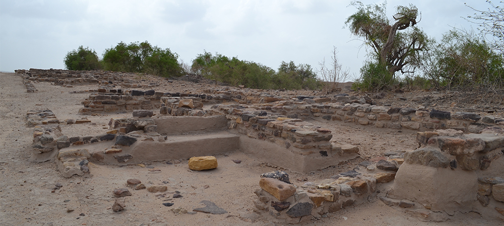
The archaeological remains of the city of Dholavira include fortifications, gateways, water reservoirs, ceremonial ground, residential units, workshop areas, and cemetery complex, all clearly representing the Harappan culture and its various manifestations. The urban planning is evident from the in situ remains of the city that demonstrate systematic planning. The authenticity of the archaeological site is preserved through minimum interventions and scientific conservation principles and methods and in maintaining the exposed structures in their original configurations and in situ conditions and no additions or alterations have been made to the structural remains.
The excavated remains bear testimony to the style of construction, contextual evidence for architectural elements, and layout of a bead manufacturing workshop, that have been retained in situ to preserve their authenticity. The evidence of the configuration of the city, which has been well documented and preserved during excavation works, also bears testimony of the extensive planning, understanding of ratios and proportions and principles, alignment of the entire city in relation to cardinal directions, water harvesting, storm water drains, craftsmanship. These features are preserved extensively due to their construction in stone masonry with mud brick cores, and architectural features are in a good state of conservation.
Protection and management requirements
The archaeological site of Dholavira is protected and managed by the Archaeological Survey of India, an attached office and organization under the Ministry of Culture, Government of India. The property is protected by national level laws that is to say the Ancient Monument and Archaeological Sites and Remains Act 1958 (AMASR), amended therein in 2010; Ancient Monument and Archaeological Sites and Remains Rules of 1959; Ancient Monument and Archaeological Sites and Remains Rules of 2011 and The Antiquities and Art Treasures Act 1972 and Rules 1973. Decisions pertaining to its conservation, maintenance and management are governed by the National Conservation Policy for Monuments, Archaeological Sites and Remains 2014. Being designated as an “ancient monument” of national importance, the ancient site of Dholavira is protected by a Prohibited Area measuring 100 meters in all directions from the limits of the protected monument, and further beyond it, a Regulated Area of 200 meters in all directions, from the limits of the Prohibited Area. All activities in the areas adjacent to the ancient site of Dholavira remain subject to prohibition and regulation in the respect prohibited and regulated areas as per provisions of the Ancient Monuments and Archaeological Sites and Remains Rules 2011. The buffer zone covers the entire west strip of the Khadir Island, which ensures the protection of the wider setting of the property. The buffer zone, of which parts cover thee Prohibited and Regulated Areas, overlaps with Kachchh (Kutch) Desert Wildlife Sanctuary which is protected by Forest Act (Wildlife Protection Act 1972). The Government of India is in the process of listing the ancient quarry sites in the buffer zone as of national importance.
The property area and buffer zone are managed by the Regional Apex Committee and Local Level Committee, with major stakeholders as the member. This participatory mechanism ensures the dialogue among different interest groups. The Site Management Plan has been approved and implemented by the Archaeological Survey of India.
Dholavira is a city of the Indus Valley Civilization in India, which lies in the north-western area of the island of Khadir Bet in the Great Rann of Kutch, Gujarat. The excavations, which started here in 1990 under the Archaeological Survey of India (ASI), have revealed ruins covering about 100 hectares. These show successive settlements, dating between the 3rd to mid-2nd millennium BCE, revealing seven significant cultural stages, which coincide with the rise and fall of the Harappan civilization.
Excavations have brought to light a model Harappan city with all its typical identifiable features. However, Dholavira's claim to fame lies in the elaborate water harvesting structures meant to save every drop of drinkable water for its people. These throw light on the geo-climatic conditions of the area and its people's high level of hydraulic engineering skills, which played an integral part in sustaining a metropolis in this arid region.
The city lay between two storm channels, the Mansar, and the Manhar, an area strewn with rocks, ridges, and natural sediments, ideally suited for building a settlement. In its mature phase, the city consisted of a bipartite citadel (Castle and Bailey), a middle town, a lower town, two stadia, an annexe, a series of reservoirs, and enormous fortifications. The water harvesting structures included check dams, reservoirs, storm-water drains and wells. Inside the city were found as many as 16 reservoirs, each one accessed through a flight of steps. The embankments and the steps are built in stone masonry and show superior workmanship.
The unique finds of Dholavira include two multi-purpose grounds (stadia), which were perhaps used for large gatherings. A 3-metre long inscription of the Indus script has been discovered near the gate of the citadel. It was made by arranging pieces of gypsum to form ten large symbols or letters on a big wooden board. Though the script has not been deciphered, but the size of the letters (37 cm high), its conspicuous location, and visibility, point to it being a kind of a signboard.
The location of this city, quite unlike that of other Indus cities situated on river banks, was probably motivated by the rich mineral wealth of the Khadir island. People sourced copper, shell, agate-carnelian, steatite, lead, and limestone and made beads, pottery, seals, ornaments, and other useful items. Highly polished, elegant stone pillar members were made, which were assembled as freestanding columns with the help of a wooden shaft that passed through a central hole that was drilled into each of the pieces. The discovery of the remains of a port at Saran, located on a rivulet 3.5 km north of Dholavira, facilitated internal and external trade to the Magan (modern Oman peninsula) and Mesopotamian regions.
The social composition appears to be diverse, as is evident from the varied funerary structures that have been found here. While society seems to have been stratified and people of different classes lived in different areas of the town, there seems to be no discrimination as far as the use of public utilities was concerned. The water reservoirs were situated so that people from all sectors of the city could make use of them.

© ASI
Author: ASI

© ASI
Author: ASI

© ASI
Author: ASI

© ASI
Author: ASI

© ASI
Author: ASI

© ASI
Author: ASI

© ASI
Author: ASI

© ASI
Author: ASI

© ASI
Author: ASI


Indian Culture App


The Indian Culture Portal is a part of the National Virtual Library of India project, funded by the Ministry of Culture, Government of India. The portal has been created and developed by the Indian Institute of Technology, Bombay. Data has been provided by organisations of the Ministry of Culture.
Email Id : indian-culture@gov.in